Caguas
Historical Overview
Founded on January 1, 1775, Caguas, known as the 'Ciudad Criolla' and the 'Valle del Turabo,' grew from a vast crown livestock territory called the 'Hato de Caguas' within the jurisdiction of San Juan. Situated in the fertile central-eastern valley, it became the regional hub connecting San Juan to the southern and eastern parts of the island. As a pueblo matriz, Caguas's original territory gave rise to San Lorenzo (1811), Gurabo (1815), and Aguas Buenas (1838). For genealogists, the Catedral Dulce Nombre de Jesús holds some of the earliest continuous interior records on the island, with baptisms dating to 1730.
Coat of Arms

Image: Wikimedia Commons (CC BY-SA 4.0)
The Caguas shield features crossed arrows representing Taíno Chief Caguax and the indigenous roots of the valley; a pineapple symbolizing the agricultural fertility of the Turabo valley; and a crown representing the patron Dulce Nombre de Jesús (Sweet Name of Jesus). The colors blue and gold signify the clear skies and waters of the valley and the richness of its Creole culture.
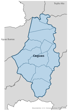
Barrios
Genealogical records often identify individuals by barrio. Caguas has 11 barrios:
Daughter Municipalities
The following municipalities separated from Caguas. Residents recorded events before their founding year in Caguas's parish:
Neighboring Municipalities
Also check records in neighboring municipalities:
Historical Maps
Historical maps help identify barrios, boundaries, and communities as they existed in the past. Maps from the 18th and 19th centuries are preferred.
Caguas (2026)
Genealogy Toolkit
Diocesan Archive
Diocese: Diocese of Caguas
For sacramental records not available digitally, contact the diocesan archive directly.
Diocese WebsiteDigital Archives
- FamilySearch: Caguas Civil and parish records
- Documentos Archivo Histórico de Caguas Digital Archive Over 150 boxes of digitized documents from the Caguas Municipal Historical Archive (1806–1955), including government correspondence, administrative records, slave registers (padrones de esclavos), and maps; more than 800,000 images available.
- Find A Grave: Caguas Cemetery Records Burial records for the Cementerio Municipal de Caguas; useful for verifying death dates and family plots from the 19th and early 20th centuries.
- Puerto Rico, Catholic Church Records, 1645–1969 Digitized Records Islandwide Catholic church-record collection including baptisms, marriages, burials, and confirmations. Includes Caguas parish records.
- Puerto Rico Civil Registration, 1885–2001 Digitized Records Civil registration births, marriages, and deaths for all Puerto Rico municipalities including Caguas, beginning 1885.
- FamilySearch: Puerto Rico Genealogy Complete records guide
Further Reading
- U.S. Census Bureau: Caguas Municipio Profile — U.S. Census Bureau Census Data Authoritative 2020 Census profile for Caguas, including official barrio list, population data, and geographic boundary information.
- Notas para su Historia: Caguas — Mario A. Rodríguez León, O.P. Local History Definitive historical text for Caguas covering the founding families, early land grants, and the history of the Dulce Nombre de Jesús parish; essential for researchers tracing ancestors in the Turabo valley before the civil registry era.
- Genus Meridiem: Caguas Genealogy Posts — César A. Zapata Lozada Genealogy Blog Genealogical research posts about Caguas families by Puerto Rican researcher César A. Zapata Lozada on the Genus Meridiem blog. Useful for family connections, archival discoveries, and local research leads.
Found an error or have additional information? Contact us