Arecibo
Historical Overview
Arecibo, known as 'La Villa del Capitán Correa,' is one of Puerto Rico's oldest municipalities, officially established in 1616 along the northern coast at the mouth of the Río Grande de Arecibo. Arecibo was founded as a daughter town of San Juan, the island's capital and original colonial center. The town holds a celebrated place in Puerto Rican history: Captain Antonio de los Reyes Correa's defense against a British naval force in 1702 earned Arecibo the honorific Muy Leal Villa and cemented its place in island memory. Over the following centuries, Arecibo served as a regional hub and mother municipality, with portions of its territory eventually forming several neighboring towns. For genealogists, the Catedral San Felipe Apóstol is the principal parish, with Catholic records accessible through FamilySearch; civil registration began in 1885.
Coat of Arms

Image: Wikimedia Commons (CC BY-SA 4.0)
The coat of arms combines Taíno, colonial, and civic symbolism. The crown at the top references Taíno heritage and the town's indigenous roots. Blue and gold lozenges in the central field honor Governor Felipe de Beaumont y Navarro and the Spanish foundation era. A belt or banda running across the shield commemorates Captain Antonio de los Reyes Correa, whose 1702 defense of the town against British forces earned Arecibo the honorific Muy Leal Villa.
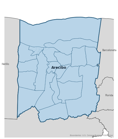
Barrios
Genealogical records often identify individuals by barrio. Arecibo has 18 barrios:
Daughter Municipalities
The following municipalities separated from Arecibo. Residents recorded events before their founding year in Arecibo's parish:
Neighboring Municipalities
Also check records in neighboring municipalities:
Historical Maps
Historical maps help identify barrios, boundaries, and communities as they existed in the past. Maps from the 18th and 19th centuries are preferred.
Arecibo (2026)
Genealogy Toolkit
Diocesan Archive
Diocese: Diocese of Arecibo
For sacramental records not available digitally, contact the diocesan archive directly.
Diocese WebsiteDigital Archives
- FamilySearch: Arecibo Civil and parish records
- Find A Grave: Cementerio Municipal de Arecibo Cemetery index
- Find A Grave: Cementerio Nuevo Municipal Urbano #3 - Arecibo Cemetery index
- Puerto Rico, Catholic Church Records, 1645–1969 Digitized Records Islandwide Catholic church-record collection including baptisms, marriages, burials, and confirmations. Includes Arecibo parish records.
- Puerto Rico Civil Registration, 1885–2001 Digitized Records Civil registration births, marriages, and deaths for all Puerto Rico municipalities including Arecibo, beginning 1885.
- FamilySearch: Puerto Rico Genealogy Complete records guide
Further Reading
- Arecibo, Puerto Rico Genealogy — FamilySearch Wiki contributors Research Guide A comprehensive municipal guide covering civil registration, Catholic church records, cemetery resources, and census research for Arecibo.
- Notas para su Historia: Arecibo — Oficina Estatal de Conservación Histórica / Gobierno de Puerto Rico Government History (PDF) An official historical reference booklet for Arecibo published by the Puerto Rico Office of Historic Preservation.
- Puerto Rico Catholic Church Records, 1645-1969 — FamilySearch Record Collection FamilySearch collection covering Catholic baptisms, confirmations, marriages, and burials for Puerto Rico, including Arecibo.
- Genus Meridiem: Arecibo Genealogy Posts — César A. Zapata Lozada Genealogy Blog Genealogical research posts about Arecibo families by Puerto Rican researcher César A. Zapata Lozada on the Genus Meridiem blog. Useful for family connections, archival discoveries, and local research leads.
Found an error or have additional information? Contact us