Bayamón
Historical Overview
Founded in 1772 from lands originally under San Juan's jurisdiction, Bayamón grew from a network of sugar ingenios into one of Puerto Rico's most populous municipalities. Known as the 'Ciudad del Chicharrón,' it anchors the metropolitan area and served as the mother town for three daughter municipalities: Guaynabo, Comerío, and Cataño. Parish records at La Invención de la Santa Cruz date to 1772, and civil registration began in 1885. Because families frequently crossed between Bayamón, San Juan, and its daughter towns, researchers should also search neighboring parishes and metropolitan-area civil registries.
Coat of Arms

Image: Wikimedia Commons (CC BY-SA 4.0)
The Bayamón coat of arms features a cross at center representing the Invención de la Santa Cruz, the town's patron. Blue and silver waves across the lower field represent the Bayamón River. A sugar mill recalls the early ingenios that drove the town's founding and economic life. Green fields symbolize the agricultural fertility that made Bayamón's separation from San Juan viable.
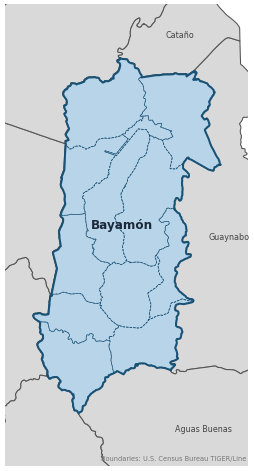
Barrios
Genealogical records often identify individuals by barrio. Bayamón has 12 barrios:
Daughter Municipalities
The following municipalities separated from Bayamón. Residents recorded events before their founding year in Bayamón's parish:
Neighboring Municipalities
Also check records in neighboring municipalities:
Historical Maps
Historical maps help identify barrios, boundaries, and communities as they existed in the past. Maps from the 18th and 19th centuries are preferred.
Bayamón (2026)
Genealogy Toolkit
Diocesan Archive
Diocese: Archdiocese of San Juan
For sacramental records not available digitally, contact the diocesan archive directly.
Diocese WebsiteDigital Archives
- FamilySearch: Bayamón Civil and parish records
- Puerto Rico National Cemetery Cemetery Records Major national cemetery located in Bayamón serving veterans island-wide. Use the Gravesite Locator at gravelocator.cem.va.gov for individual searches.
- Find A Grave: Bayamón Cemetery Records Crowdsourced index of interments for municipal and private cemeteries in Bayamón.
- Puerto Rico, Catholic Church Records, 1645–1969 Digitized Records Islandwide Catholic church-record collection including baptisms, marriages, burials, and confirmations. Includes Bayamón parish records.
- Puerto Rico Civil Registration, 1885–2001 Digitized Records Civil registration births, marriages, and deaths for all Puerto Rico municipalities including Bayamón, beginning 1885.
- Bautismos 1752-1785 — Iglesia Santa Cruz, Bayamón Church Records Baptismal records 1752-1785 for Iglesia Santa Cruz (Invención de la Santa Cruz), Bayamón, Puerto Rico. Part of the Puerto Rico Catholic Church Records collection on FamilySearch.
- Bautismos 1798-1859 — Iglesia Santa Cruz, Bayamón Church Records Baptismal records 1798-1859 for Iglesia Santa Cruz (Invención de la Santa Cruz), Bayamón, Puerto Rico. Part of the Puerto Rico Catholic Church Records collection on FamilySearch.
- Bautismos 1828-1836 — Iglesia Santa Cruz, Bayamón Church Records Baptismal records 1828-1836 for Iglesia Santa Cruz (Invención de la Santa Cruz), Bayamón, Puerto Rico. Part of the Puerto Rico Catholic Church Records collection on FamilySearch.
- Bautismos 1836-1843, matrimonios 1897-1911, defunciones 1774-1865 — Iglesia Santa Cruz, Bayamón Church Records Combined volume: baptismal records 1836-1843, marriage records 1897-1911, and death records 1774-1865 (with gaps between 1794 and 1821) for Iglesia Santa Cruz, Bayamón, Puerto Rico.
- Bautismos 1856-1878 — Iglesia Santa Cruz, Bayamón Church Records Baptismal records 1856-1878 for Iglesia Santa Cruz (Invención de la Santa Cruz), Bayamón, Puerto Rico. Part of the Puerto Rico Catholic Church Records collection on FamilySearch.
- Bautismos 1878-1895 — Iglesia Santa Cruz, Bayamón Church Records Baptismal records 1878-1895 for Iglesia Santa Cruz (Invención de la Santa Cruz), Bayamón, Puerto Rico. Part of the Puerto Rico Catholic Church Records collection on FamilySearch.
- Bautismos 1895-1912 — Iglesia Santa Cruz, Bayamón Church Records Baptismal records 1895-1912 for Iglesia Santa Cruz (Invención de la Santa Cruz), Bayamón, Puerto Rico. Part of the Puerto Rico Catholic Church Records collection on FamilySearch.
- Bautismos 1910-1917 — Iglesia Santa Cruz, Bayamón Church Records Baptismal records 1910-1917 for Iglesia Santa Cruz (Invención de la Santa Cruz), Bayamón, Puerto Rico. Part of the Puerto Rico Catholic Church Records collection on FamilySearch.
- Bautismos 1910-1927 — Iglesia Santa Cruz, Bayamón Church Records Baptismal records 1910-1927 for Iglesia Santa Cruz (Invención de la Santa Cruz), Bayamón, Puerto Rico. Part of the Puerto Rico Catholic Church Records collection on FamilySearch.
- Bautismos 1927-1931, matrimonios 1750-1897 — Iglesia Santa Cruz, Bayamón Church Records Combined volume: baptismal records 1927-1931 and marriage records 1750-1897 (with gaps between 1787 and 1796) for Iglesia Santa Cruz, Bayamón, Puerto Rico.
- Defunciones 1866-1891 — Iglesia Santa Cruz, Bayamón Church Records Death records 1866-1891 (with gaps between 1884 and 1885) for Iglesia Santa Cruz (Invención de la Santa Cruz), Bayamón, Puerto Rico.
- Índice de bautismos 1765-1939, índice de matrimonios 1750-1911, defunciones 1884-1901 — Iglesia Santa Cruz, Bayamón Church Records Index volume: baptism index 1765-1939, marriage index 1750-1911, and death records 1884-1901 for Iglesia Santa Cruz (Invención de la Santa Cruz), Bayamón, Puerto Rico.
- FamilySearch: Puerto Rico Genealogy Complete records guide
Further Reading
- U.S. Census Bureau: Bayamón Municipio Profile — U.S. Census Bureau Census Data Authoritative 2020 Census profile for Bayamón, including official barrio list, population data, and geographic boundary information.
- Notas para su Historia: Bayamón (PDF) — Fr. Mario A. Rodríguez León, O.P. Book Essential scholarly text covering Bayamón's history, rooted in the sugar industry and its evolution into a major industrial center.
- Genus Meridiem: Bayamón Genealogy Posts — César A. Zapata Lozada Genealogy Blog Genealogical research posts about Bayamón families by Puerto Rican researcher César A. Zapata Lozada on the Genus Meridiem blog. Useful for family connections, archival discoveries, and local research leads.
Found an error or have additional information? Contact us